NOAA Fisheries developed reports summarizing fishing activity from 2008-2018 within each offshore wind lease or project area along the U.S. Atlantic Coast (for more information on individual offshore wind leases, see Bureau of Ocean Energy Management website). For commercial fishing trips, these reports highlight annualized landings and revenue by species, gear type, and fishery management plan within each area, as well as revenue by port and vessel dependence upon operations in each area. Party/charter reports highlight annualized kept catch by species and management category (a proxy for fishery management plan), annualized revenue based on passenger fees and number of anglers per trip, annualized vessel and angler trips by port, and vessel/angler dependence upon operations in each area. Both reports can be used to help identify the major species harvested, affected fishery operations, potential revenue impacted, and ports affected by offshore wind development in each area. Such information can help prepare fisheries monitoring plans and socioeconomic impact analysis.
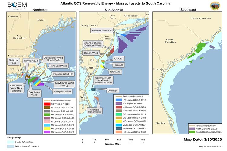
The commercial fishing summaries are based on combining data from vessel trip reports (logbooks) and dealer reports submitted by those issued a permit for managed species in federal waters (i.e., outside of three nautical miles from shore). The methods used to determine area fished for each trip from logbook data are similar to those used to develop our Fishing Footprints page. The party/charter fishing summaries are based on combining kept catch and angler data from logbooks submitted by vessels issued a federal party/charter permit with the average annual angler fee per state derived from periodic NOAA surveys of party/charter operators (see Lovell et al., 2020).


The Curious Cart Conundrum 'Twas a sunny day by Chesapeake Bay, Our little golf cart rolled with cheer. We sought…
Back in '67 while at jungle warfare training school prior to deploying to RVN we had a nutty instructor who…
Rocky's reasoning skills are seriously flawed because if this “rag” really were controlled by “Commie Central," we wouldn't be talking…
I'll be happy when I no longer get random batches of gray or yellow water in my house. Flushing the…
It is a very sad fact that folks, today, can't back up their vehicles without the help of a camera,…