With the stranding of the third whale in the last three weeks, the Mirror contacted NOAA fisheries about the fatalities. According to the North Atlantic office, “…these recent stranding events, the three humpback whales stranded in Virginia within the past two weeks that have all shown signs consistent with ship strike. This is a geographic area with a high amount of vessel traffic. When whale prey and feeding areas overlap with shipping lanes, ship strikes can occur.” Whales tend to cluster around the mouth of the bay to feed during a southerly migration – with menhaden in the area, it can be a great place to tank up before continuing south.
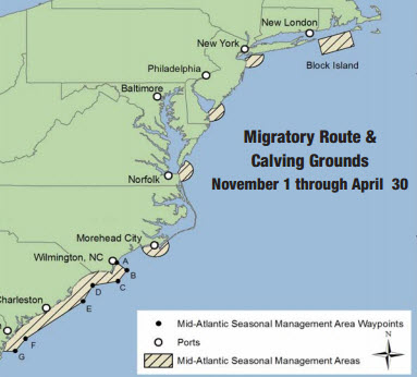
The Ship Strike Reduction Rule (50 CFR 224.105), requires that vessels may operate at a speed greater than 10 knots only if necessary to maintain a safe maneuvering speed in an area where conditions severely restrict vessel maneuverability as determined by the pilot or master.
If a deviation from the 10 knot speed restriction is necessary, the following information must be entered into the logbook:
– Reasons for deviation
– Speed at which vessel is operated
– Latitude and longitude at time of deviation
– Time and duration of deviation
– Master of the vessel shall sign and date the logbook entry
While the rule is mainly for the endangered northern right whale, it is useful for all whale species.
 The Mirror followed with NOAA, “Who is responsible for enforcing the 10 knot speed as part of the Ship Strike Reduction Rule? In Hampton Roads, we have had 3 whale deaths in 2 weeks, which appear to be the result of ship strikes around the Chesapeake Bay Bridge Tunnel. These ships entering the mouth of the Bay, which is part of the restricted area this time of year, are traveling well over 10 knots. They are supposed to log these speeds, but where is it logged and how can the public find that data?”
The Mirror received this email response, “Thank you for your concern about the recent humpback whale deaths reported in Virginia. The vessel speed reduction rule is primarily enforced by NOAA Fisheries Office of Law Enforcement (OLE). Mariners and ship captains are required to make notations in a ship’s log book when deviating from the required speed. OLE monitors compliance with the rule through a number of methods, which may include a review of ships’ logbooks. These logbooks are not publicly available. If you suspect a violation, please report it to OLE at 1-800-853-1964.”
The Port of Virginia reports an average of 40 large container ships enter the port each week. Anyone that spends any amount of time on the water understands that these large vessels are traveling well over 10 knots, and more than likely are not watching out for whales.
While NOAA and the USCG are ultimately responsible for vessel traffic in the Hampton Roads area, more education for pilots may be required. The Coast Guard broadcasts warnings to mariners to slow down when northern right whales are around, but large pods of humpbacks may not get reported. There are tools and strategies available.
A phone app for iPhone and android, Whale Alert helps reduce the chance of fatal ship strikes by large vessels by displaying active whale management areas, required reporting areas, recommended routes, areas-to-be-avoided and near real-time warnings in shipping lanes along both coasts of the United States and Canada. This information allows vessel operators to avoid collision with whales by slowing down and heightening their visual awareness. More importantly, It also supports reporting of whale sightings by the maritime community and the broader public. This information is shared in real-time with leading whale researchers and state and federal management authorities. In some cases, whale sightings will trigger confirmation “over-flights” by the National Marine Fisheries Service (NMFS) or the United States Coast Guard (USCG) who will then determine whether or not temporary speed restrictions should be created (Dynamic Management Areas).
NOAA also provides an Interactive North Atlantic Right Whale Sightings Map (http://www.nefsc.noaa.gov/psb/surveys/)
The Northeast Regional Office conducts mariner outreach, collects information on ship strike events, participates in NOAA’s national Ship Strike Reduction Strategy and funds and coordinates aerial surveys and research programs to improve our understanding of vessel collision events and develop effective programs to further reduce the threat of ship strike to whales.
As NOAA reiterates, collision with vessels is the leading human-caused source of mortality for the endangered North Atlantic right whale. Encouraging responsible boating practices and understanding the distribution of all whales are two key components to reducing the risk of ship strike.


In hindsight, the most surprising thing is that this has not occurred sooner. I’ve observed large numbers of humpback whales at Cape Henry as far back as the early 1990s. This also happens to be the southern entrance for shipping traffic to the Chesapeake Bay, so the potential for conflict is obvious. Keeping a lookout for the whales isn’t very helpful unless you just give the whole area a wide berth, because they surface suddenly and you never know where that will be next. Perhaps there has been a slight alteration in either the area where the whales are feeding or in the ship traffic route. Could it be related to the recent move in anchorage to off Cape Charles? That seems counterintuitive since the main feeding grounds I’ve noticed are right at the tip of Cape Henry, unless maybe in the past ships approaching Cape Henry were traveling slower in preparation for anchoring off Lynnhaven.