The United States and Taiwan on Thursday signed their first agreement under the Biden administration, establishing a Coast Guard Working Group to coordinate policy, following China’s passing of a law that allows its coast guard to fire on foreign vessels.
The new government of US President Joe Biden has moved to reassure Chinese-claimed Taiwan that its commitment to the island is rock solid.
The question is, if China wants to move on Taiwan, just what is the US response going to be? It may not be the outcome you’d expect, and may be a major embarrassment to US forces deployed in the South China Sea.
In late January 2019, China released footage showing off its new intermediate-range ballistic missile, the Dongfeng (“East Wind”) DF-26. The DF-26 has been dubbed the “Guam Killer”.
All war is about terrain and resources – these are the raw materials of power. And when multiple entities decide they MUST control a certain place or asset, conflict is inevitable. One such place is the South China Sea. The South China Sea is the geographic location that is keeping the brightest and most connected military thinkers awake at night. Sprawling 3.5 million sq km, the SCS is a shared body of water touching multiple key nations, and is a critical chokepoint for global trade.
Approximately 1/3 of the value of all global trade (~$3 trillion/yr) transits the SCS. It is the main route for all Chinese on-water trade to Europe, Africa, and the Middle East. Many shipments to/from the Americas must also transit the SCS.
Given its implacable geographic limitations, the region is a true zero-sum pie. Any strategic advance for one nation comes at a cost to the others. China, and all of its neighbors, have every reason to maximize their own stake in the SCS region. Though China prefers subversion and multi-layered strategies at the global scale (see my threads on #BeltandRoad at the end of this one), they are a bully in their own backyard. Going back as far as the Sino-Vietnamese War in 1979, China pushes the limits.
There is a diplomatic geography as well. The US has littered the region with “tripwire” agreements that obligate us to rise to the defense of Japan, Philippines, Thailand, SKorea, and Taiwan in the event of Chinese aggression. Given the strategic importance of the region and the interdependence of rival nations upon the SCS, China knew that any overly-hostile act would do more harm than good. Their best bet was to simply begin staking territorial claims in the international waters.

However, the SCS is free of any significant mid-sea landmasses, outside of the tiny Paracel and Spratly archipelagos (island chains). These miniscule islands were not durable enough for any form of infrastructure, and so could not be claimed via “squatter’s rights”.
Since 2013, the nation has invested countless dollars and man-hours into dredging and building of artificial islands throughout the Spratly and Paracel chains, with 3200 acres of new “land” in the Spratlys alone.
This is a very different pattern of behavior than China has used in #BeltandRoad projects. But, there’s a common thread: The buildout of DUAL-USE infrastructure. Despite the claims of peaceful civilian/maritime uses, the assets are ideal for military use.
China is a master of the weaponized Hegelian Dialectic: Problem–>Reaction–>Solution They create a problem that provokes a specific reaction, leading to their solution. Synthesis of a fabricated issue in a way that favors China. Seem familiar? The axis of the world turns upon control of four resources: Protein Water Energy Firepower The first is the subject of this thread. China’s enormous population demands massive amounts of protein. And war is on for it.
Having established the “what”, we can now explore the “why”. “Logistics is a map of human intent”, let’s look at the assets themselves to infer intent. 𝘎𝘦𝘰𝘨𝘳𝘢𝘱𝘩𝘺 𝘐𝘯𝘧𝘳𝘢𝘴𝘵𝘳𝘶𝘤𝘵𝘶𝘳𝘦 𝘊𝘢𝘱𝘢𝘣𝘪𝘭𝘪𝘵𝘪𝘦𝘴. The easternmost landmasses in the Spratly Islands sit a mere 130 km from the Philippines’ Palawan Island. The Paracels are less than 350 km from Vietnam. However, by occupying these two chains in tandem, China is mounting a claim that their “littoral” (coastal) waters now extend an incredible 1260 km from the Chinese coast. They’ve effectively annexed the entire South China Sea as sovereign Chinese territory.
This has massive implications across the commercial, geopolitical, and military domains. The obvious one is that by making this critical sea-route a part of China, they could begin charging tolls to the massive number of ships that transit the waters daily.
This is the Fiery Cross Reef in the Spratly chain. Fully completed in 2017, satellite imagery shows something startling – a full-scale airport in the middle of the SCS. This is no small feat of finance or engineering.

In addition, China’s dredging operations resulted in deep-water harbors at the Subi and Mischief Reefs. Island supply chains depend on maritime support. Flying in fuel, consumables, assets, and building materials is cost-prohibitive long term. Logistics doesn’t lie.
The location of Subi Reef’s naval base is no mere coincidence. I’ve bracketed the primary maritime route through the SCS in orange. Maritime law enforcement, interdiction, and military operations are all easily supported, while also funneling vessel traffic.
As one can see, the infrastructure and geography enable significant combined military operations across air, land, surface, and subsurface domains in the SCS. However, just as important to China is the ability of these islands to extend a defensive perimeter even further.
Any nation concerned with mainland defense against the United States will be aware of the tremendous firepower our Navy brings to bear. We can deliver crushing force from far-out on water. Distance is a defender’s best ally against the US Navy. A single USN carrier strike group boasts: – Nimitz-class aircraft carrier (up to 90 aircraft) – Guided missile cruiser (w/ Tomahawk cruise missiles) – 2 guided missile destroyers – Resupply vessel – Attack submarine The cruiser and sub are the key assets here. A Ticonderoga-class cruiser or Los Angeles-class submarine armed with Block III Tomahawks has an effective strike range of more than 1600 km. At that range, the Chinese mainland is reachable from nearly anywhere in the SCS. The defensive bubble must be pushed out further.
Recognizing this, in 2017 China began installing advanced A2/AD (anti-access/area denial) surface-to-air missile batteries on several of their SCS island claims. This map shows the effective range of the batteries for the known SAM assets on the islands.
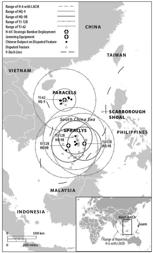
Even more menacing, however, is deployment of the DF-26 to the SCS theater in July of this year. An intermediate-range ballistic missile, the DF-26 is highly versatile and capable of destroying ships or ground targets at more than 5,000 km. Guam is no longer safe. Guam is home to a critical US installation called Naval Base Guam. It is a major base for the entire Pacific theater, supporting naval operations for the USN Seventh Fleet. It is attractive for its own distance from traditional missile strikes.
While a conventional warhead on the DF-26 would do massive damage to a ship or ground installation, the missile is also reputed to be nuclear-capable. This has earned the DF-26 the nickname “Guam Killer”. And if Guam isn’t safe, the entire SE Asia theater isn’t.
It is not that China simply wants to control some islands. This is about an strategic realignment of power in the entire region. The Seventh Fleet was once alpha dog. No more. For decades, the US Navy’s blue-water prowess has buttressed US diplomatic and economic efforts with the subtle threat of overwhelming force. But there’s a logistical limit to this paradigm: Distance.
If an adversary can push the US Navy beyond its practical logistical limits by building a big-enough integrated air defense system (IADS), then the US’ biggest stick is broken. The point of an effective IADS is to build overlapping layers and modes of defense.