Northampton: Atrocity at Old Neck Road
In September of 2016, a tip came in that there had been some environmental damage at the property located at 2281 Old Neck Road in Exmore. The Northampton Wetlands Board, expecting a routine violation, were instead shocked to find one of the worst environmental events in recent history. The property, owned by Benjamin Mathai of Manassas, Virginia had been clear cut from the back property to the point, destroying and disturbing not only tidal wetlands, but a large swath of the state’s Resource Protection Area. Grasses and dirt were removed using heavy construction equipment, and a large mass of old, historic loblolly pines were cut down. This work was done without a permit.
After a thorough investigation, it was determined that the property was impacted by unauthorized clearing activity using manual labor, chain saws and moving equipment and created disturbances to all three environmental sensitive regions-tidal wetlands, non-tidal wetlands and the Chesapeake Bay Resource Protection Area (CCPA buffer). The disturbance can be characterized by felled old growth loblolly pines, and soil disturbance with tractor tracks and tree dragging. Unwanted debris such as limbs and felled trees covered and impacted the growth of sensitive vegetation and soils. The affected areas are in the supratidal zone (the area above the spring high tide line). Vegetation that was removed consisted mainly of American beach grass, salt marsh hay, salt bush and some phragmities. [Read more…]
Health Professionals, Farmers, Business Owners Support Legislation to Combat Antibiotic Resistance
The “Keep Antibiotics Effective Act” is before Senate and House Committees this week.
The Centers for Disease Control (CDC) very conservatively estimates the number of antibiotic resistant infections in the United States at around 2 million cases a year. Of those, 23,000 people will die as a result of the resistant infection. The annual cost in the United States of such infections exceeds $55 billion per year. Bacteria resistant to antibiotics are increasing, which means infections from common injuries and surgeries are increasingly risky and can be life threatening. Recently, a Nevada woman died of a hip infection resistant to all existing antibiotics.
One of the reasons for this resistance is the ongoing, low-dose use of antibiotics in the agriculture sector, where up to 70 percent of human antibiotics are sold for use in animals.

Image (Vegan Peace)
Legislation in the Maryland General Assembly this year aims to limit the use of antibiotics in farm animals that are not sick. The Keep Antibiotics Effective Act of 2017, sponsored by Sen. Paul Pinsky and Sen. Nathan-Pulliam (Senate Bill 422) and Del. Shane Robinson (House Bill 602) would allow the use of antibiotics in farm animals that are sick, having a medical procedure, or for disease control, but prevents the routine, low dose usage. Low dose use is most likely to breed resistance.
A hearing took place on Tuesday, Feb. 14 in the Senate Education, Health and Environmental Affairs Committee. The House hearing in the Environment and Transportation Committee is scheduled for Feb. 15 at 1 p.m.
[Read more…]
Stranded Whale at Butlers Bluff
The second stranded humpback whale in so many weeks was found along the beach near Butlers Bluff. The Mirror contacted the Virginia Aquarium where testing is still being done to confirm the findings, according to Matt Klepeisz, the aquarium spokesman. “The whale was in an advanced stage of decomposition, so it may hinder efforts,” Klepeisz said. The Aquarium is leaning toward the conclusion the first whale, found on February 2nd was killed by a propeller strike, however pathology reports have yet to confirm this.

(Chris Glennon Photo)
“We had a pretty strong suspicion last week based on the fact that there were four really large propeller chop wounds in it. But we had to get inside and look for the evidence that those wounds occurred when the animal was still alive, because dead animals do get run over after they die,” said Alex Costidis with the Virginia Aquarium and Marine Science Center.
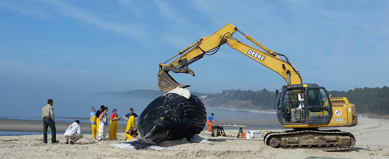
Crews from the Virginia Aquarium use heavy equipment to perform a necropsy on the stranded whale (Photo Christina Janoski-Travis)
While whale deaths are somewhat uncommon in these waters, they are more frequent in the heavily traveled seas along the northeast seaboard.
A 2012 study, led by Julie van der Hoop of the Woods Hole Oceanographic Institution in Massachusetts, looked at 1,762 known deaths and likely fatal injuries from 1970 to 2009 among eight species of big whales. A cause of death had been determined in 750 of the cases (around 42 percent), and of those, nearly 67 percent of the fatalities were human related. Getting ensnared in fishing gear was the leading cause of death across all species, killing 323 whales, while vessel strikes took the lives of 171 more. Meanwhile, 248 whales died of causes not directly related to humans, such as an infection, stranding or natural causes.
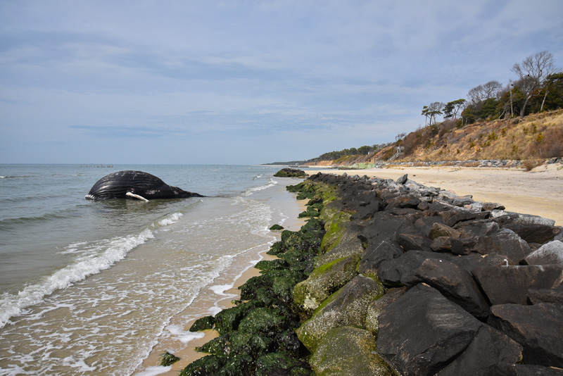
Photo Chris Glennon
Given that at least one of these deaths more than likely occurred via vessel impact, some have begun to question whether increased cargo traffic near the mouth of bay which is occurring as more vessels are having to anchor off Cape Charles, is having an impact on migratory species such as whales, which are moving south for mating season. NOAA has listed the mouth of the bay as watch area for whales during this time of year. The Mirror attempted to contact the USCG to find out whether shipping lanes have been, or will be changed for the southern portion of the Chesapeake Bay near Cape Charles and the CBBT to accommodate traffic to the anchorages off Cape Charles. The Mirror also inquired whether an impact study on the effects to migratory animals was done as part of the process. The USCG has not responded as of this publishing.
Harbor Seals Back on the Eastern Shore for a Winter Vacation
The Northeast Fisheries Science Center, a federal research arm based in Woods Hole, Massachusetts is reporting increases for gray seals and harp seals. Springtime estimates for harbor seals along the Maine coast nearly tripled to more than 75,000. A few of these 75k seem to enjoy vacationing on the northern islands of the CBBT once the water temperatures drop off, especially around the third island. According to the Virginia Aquarium and Marine Science Center in Virginia Beach, the first seals start arriving in December and the number picks up through March before they head back north.
The Mirror contacted the Virginia Aquarium, and while a seal survey count has not taken place, there have been several sightings. Estimates are around 20 to 24 seals visiting this season.

Harbor Seal basking in the sun on the rocks of the CBBT (Image Vicki Cronis-Nohe – Virginia Pilot)
The Aquarium offers a Seal Spotting Sea Adventure, running in January, but please confirm availability on the link listed below. Here’s a brief description:
Seals are frequent visitors to this area when the water temperatures drop, although their favorite haul out spots can make them difficult to see. During this 2.5 hour trip, catch eye-level observations while educators from the Aquarium provide information about the species that frequent our waters. Tickets are $28 for ages 12+ and $24 for ages 3-11. Tickets can be purchased at http://tickets.virginiaaquarium.com/default.asp?cgCode=14&cgName=Sea%20Adventures%20Boat%20Trips
The Virginia Aquarium stranding team asks, so it can do population surveys, that sightings be reported to 757-385-7575 along with a picture or video if possible.
Sea Turtle Recovery, New Jersey’s Newest Rehabilitation Center, Admits First Patients
The first injured sea turtles arrived Wednesday night at New Jersey’s new and only long-term sea turtle rehabilitation center, the Sea Turtle Recovery at Essex County Turtle Back Zoo in West Orange, New Jersey. The 10 Kemp’s ridley sea turtles were transported from the New England Aquarium in Massachusetts, where the season has already brought nearly 450 cold-stunned sea turtles ashore in the state.
![]() “For more than six years, I helped transport sea turtles that needed surgery or long term treatments as far as North Carolina to receive care,” said co-executive officer Brandi Biehl of the Sea Turtle Recovery non-profit organization. “Now, thanks to support from Essex County and the public, we can treat sea turtles right here in the state and provide assistance to other facilities in the Northeast that become overcrowded.”
“For more than six years, I helped transport sea turtles that needed surgery or long term treatments as far as North Carolina to receive care,” said co-executive officer Brandi Biehl of the Sea Turtle Recovery non-profit organization. “Now, thanks to support from Essex County and the public, we can treat sea turtles right here in the state and provide assistance to other facilities in the Northeast that become overcrowded.”
[Read more…]
Finding Common Ground with the Eastern Shore Poultry Industry
Special Letter to the Cape Charles Mirror by Ken Dufty
I appreciate this opportunity to add to the comments of Perdue’s Steve Levitsky regarding finding common ground regarding the poultry expansion on the Delmarva Peninsula, and especially on the Eastern Shore of Virginia. [December 13,Eastern Shore Post]. As your readers know, we here in Northampton County are just surfacing from a 30 month fight to protect our rural quality of life and pristine natural resources, so this expansion in our sister county to the north does arch an eyebrow more than a bit.
Last week, a new group formed to explore manure-to-energy solutions to process the waste generated by the poultry industry was introduced to the lower Shore by Virginia’s Eastern Shorekeeper during a public symposium in Onancock. [Read more…]
How soon will Cape Charles be Underwater?
Scientific research indicates sea levels worldwide have been rising at a rate of 0.14 inches (3.5 millimeters) per year since the early 1990s. The trend, linked to global warming, puts thousands of coastal cities, like Cape Charles at risk of being submerged by the ocean.
Climate Central has produced a Surging Seas global Risk Zone Map which provides the ability to explore local sea level rise projections at over 1,000 tide gauges on 6 continents. Map areas below the selected water level are displayed as satellite imagery shaded in blue indicating vulnerability to flooding from combined sea level rise, storm surge, and tides, or to permanent submergence by long-term sea level rise. Map areas above the selected water level are shown in map style using white and pale grays.
This analysis used the best available U.S. national coverage elevation dataset at the time. Risk Zone Map now uses far more accurate laser-based (lidar) elevation data in the U.S.
Outside of the U.S., very little lidar data is available. Instead, we use radar satellite-based data collected from NASA’s Shuttle Radar Topography Mission (SRTM). This elevation data covers nearly the entire populated world, but is less accurate than lidar. SRTM’s pixel resolution is lower, and in areas of dense urban development and vegetation, SRTM tends to overestimate elevation. Recent work also suggests that SRTM usually underpredicts exposure from sea level rise and coastal flooding. Outside the U.S., our flood maps should therefore be seen as likely lower bounds on the extent of potential inundation for each water level. View the map below:
Kiptopeke Wants Your Christmas Trees
Citizen submitted report to the Cape Charles Mirror
Inspired by the research of wetland scientists in the Netherlands, the Jefferson Parish in Louisiana took discarded Christmas trees and—rather than abandoning them in a landfill—used the trees to protect and help restore the marsh. They are used to construct shoreline fences, creating a wave break to slow land erosion. With calmer water between the fence and the shoreline, vegetation has an opportunity to grow.
Here on the Eastern Shore, Kiptopeke is looking for donated Christmas trees to help protect our shoreline.
Kiptopeke State Park wants your natural Christmas trees for dune stabilization.
Drop from Monday, 26 Dec through Tuesday, 10 January, between 8 AM and 4 PM.
Leave trees at the Kiptopeke beach, next to the sign near the bathhouse.
Call the park at 757-331-3402 with questions.
PS: Remove all decorations, including tinsel !

Ghost Pots continue to Haunt Chesapeake Bay
Whether through deliberate abandonment or through accidental loss, derelict traps have significant negative effects on both the economic and ecological status of the Chesapeake Bay. A new report from NOAA, Ecological and Economic Effects of Derelict Fishing Gear in the Chesapeake Bay, estimates that 12% to 20% of blue crab pots deployed annually in Chesapeake Bay waters are lost or abandoned at any given time, and that that there are 145,000 derelict crab pots Bay-wide (non-depreciated replacement gear value between $3.6 and $5 million).
 The report is based data produced and coordinated by the Virginia Institute of Marine Science.
The crabbers removed more than 34,000 derelict pots during the six-year run of the program, paid for with $4.2 million in U.S. Commerce Department disaster-relief funds. The study, led by VIMS assistant professor Andrew Scheld, estimated that taking out all those pots generated $21.3 million worth of increased commercial catches – 27 percent more than otherwise would have been caught in the areas covered by the program.
As our local Eastern Shorekeepers have noted in the past, derelict pots capture and kill millions of blue crabs per year, amounting to nearly 5% of the commercial harvest. Inadvertent by-catch, such as white perch and Atlantic croaker are also affected.
Derelict gear may impose a variety of economic costs. The costs of decreased harvests due to ghost fishing can be further separated into those which are caused by stock reductions. In fisheries with large amounts of effort and gear loss, such as blue crab fisheries in the Chesapeake Bay, the economic costs of inefficient gear may be significant. The report notes that the 43,968 removals which occurred in Maryland and Virginia from 2008-2014 are thought to have resulted in an additional 38.17 million lbs of harvest valued at $33.5 million. In a nutshell, Chesapeake Bay waterman might obtain crab at a much lower cost, were it not for derelict gear.
The report notes that targeted derelict pot removal in high density areas, enforcement of the removal of abandoned pots, education of recreational boaters to minimize use-conflict, and pot modifications that include a biodegradable escape mechanism offset the adverse ecological and economic effects of ghost pots. [Read more…]
- « Previous Page
- 1
- …
- 39
- 40
- 41
- 42
- 43
- …
- 56
- Next Page »